Smaller rivers within the Natchaug River watershed are a focus for healthy waters
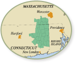
Here at The Last Green Valley, Inc. (TLGV) we value our role documenting and advocating for the region’s rivers. Water from the Quinebaug and Shetucket Rivers, and the smaller rivers, streams and brooks that feed them, flow southward into the Thames River and Long Island Sound. The lands surrounding these waterways comprise the Thames River watershed, and every one of The Last Green Valley National Heritage Corridor’s 35 towns is within the watershed boundaries.
These waters are critical to the region’s ecological health and recreational opportunities, and they help define our shared history and culture. I have come to experience most of our rivers through paddling excursions, riverside hiking trails and TLGV’s volunteer water quality monitoring program.
In previous columns I have shared information about our larger rivers, especially the recreational paddle opportunities they provide. Over the next few months I will share information about our smaller rivers, brooks and streams and hope you’ll come to appreciate the value of these waters as much as I do. Today we explore Bigelow Brook and the Still River, both within the Natchaug River watershed area (a sub-watershed area within the larger Thames watershed).
In our state there are at least two rivers that carry the name Still River. Our region’s Still River has headwaters in Union and then meanders through forest into Woodstock and Eastford where it is visible from the east side of Route 198. For 30 years I lived on Route 198, so I am familiar with the Still River, as are the fisherman I see parked along the road on opening day of fishing season as well as those who reside along its banks.
Bigelow Brook flows out of Mashapaug Lake in Union into Bigelow Hollow State Park and Bigelow Pond. Like the Still River, it is mostly a forest river and flows through the Nipmuck Forest as well as the Yale-Myers Forest. From Union it flows southwest into Myers Pond then continues south and serves as the border between Ashford and Eastford. It then flows east into Eastford then turns south again where it joins the Still River to form the Natchaug River.
The Natchaug then flows south and west through the Town of Chaplin and empties into Mansfield Hollow Lake. The lake is managed by the U.S. Army Corps of Engineers and is comprised of water from not only the Natchaug, but also the Fenton and Mount Hope Rivers. Water from the lake is released through a system of dams and control gates, and the Natchaug River continues its journey southward to form the Willimantic Reservoir. The reservoir provides clean drinking water for the Town of Windham.
It was from Eric Thomas, CT DEEP Watershed Manager and the Governor’s designee to the TLGV board, that I first heard the saying “we all live downstream.” Clearly the value of the Still River and Bigelow Brook is greater than just their beauty and recreation opportunities. Both flow through predominately intact forests that serve as nature’s filter system, thereby helping to ensure the cleanliness of drinking water for thousands of people. Those who live “downstream” of both of these rivers are lucky.
Two years ago, I wrote a column about the Natchaug River Basin Conservation Compact, a working document focused on conservation strategies that would protect and restore water quality within the watershed. The factors that drove the compact are still relevant today. Here is a quick summary:
- Conservation professionals from several fields as well as community leaders identified the most valuable resources within the watershed, listed threats to those resources and developed a prioritized list of actions to alleviate those threats in the form of a conservation action plan.
- The compact was meant to protect the Natchaug watershed, which is the largest surface water public drinking supply watershed in the state, and the Natchaug River, which is the healthiest river of its size in the state and a benchmark watercourse by which others are measured.
- The Natchaug watershed is home to people from the towns of Ashford, Chaplin, Eastford, Mansfield, Union, Willington, Windham and Woodstock. Its rivers are rich in history. These waters have provided fishing and hunting grounds, rich soils and clear water for farms and have powered mills.
- The Natchaug River Basin Conservation Compact recognizes the towns in the basin comprise a river community and the actions of the community will affect how healthy the watershed remains. Signing the compact was recognition by all eight towns that more than 60,000 people depend on the basin’s waters. The compact is a commitment from the eight communities to work together on behalf of the watershed.
More recently the Eastern Connecticut Conservation District has been the recipient of a grant from the Environmental Protection Agency to complete a Healthy Watershed Initiative Project in the upper Natchaug River, in Woodstock, Union, Eastford, Chaplin and Mansfield. As this watershed is considered the least-degraded river system in our region, the project will focus on policies to keep it clean. This is the first Healthy Watershed Initiative Grant awarded in Connecticut.
This year a group of water resource professionals, community leaders and other interested folks began a series of meetings to develop the Natchaug River Healthy Watershed Initiative. Their work will help communities and landowners understand specific issues of concern for the health of the watershed and establish benchmarks for working together to ensure the current and future cleanliness and vitality of the Natchaug River watershed.
The Still River, Bigelow Brook and their smaller tributaries form the Natchaug and are critical to the work of the initiative. I am participating at the initiative meetings and look forward to reporting on its work in future columns.
We live in a special place called The Last Green Valley. The Still River and Bigelow Brook are important water sources, and though smaller in size than our larger rivers, they are critical to our region’s precious resource – clean water. Thankfully, many people are working together to ensure they remain clean and healthy.
Bill Reid is the Chief Ranger of The Last Green Valley National Heritage Corridor and has lived in the region for more than 35 years. He can be reached at bill@tlgv.org
Get Connected
Sign up for our newsletter


